3d image of property in bristol

Bristol Drones — Drone Surveying & Mapping

Bristol Drones provides high-quality surveying and mapping services across the South West.

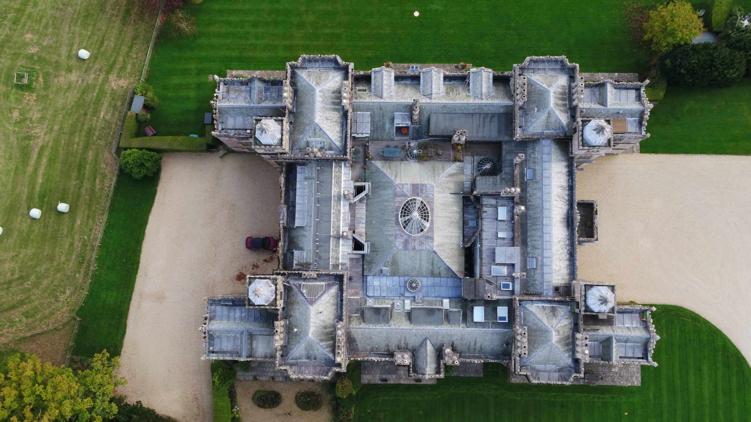
We’re a certified and insured drone services provider based in Bristol using the latest and best drone technology, including the Dji Matrice 210, Inspire 2, eBee SQ, Matrice 600 and Mavic 2 Pro.

Our drone surveying and mapping services are efficient, accurate, and cost-effective — which is why we’re used by clients throughout Bristol, Bath, Swindon, and the South West. ​

Read on to find out more about Bristol Drones Surveying & Mapping Services.

Benefits of drone surveying & mapping

Using a drone service for surveying and mapping has many different benefits:

  • Drone surveys are efficient and time-saving: traditional methods of obtaining data normally require high levels of surveying workforce numbers, and the acquisition of this data can often be time-consuming, difficult to manage, and difficult to keep up to date. Drones can cover large areas and map them out very quickly.
  • Because drone surveying and mapping is quicker and more efficient, it is also much more cost-effective than traditional data collecting methods (especially in comparison to helicopters). Bristol Drones works hard to keep costs and time to a minimum to fit your budget; check out our prices page for more information regarding a free quotation and consultation.
  • Using drones for surveying and mapping is the safest option you can pick. When carrying out these tasks manually, there can be all sorts of health and safety risks at play — particularly if you’re trying to capture inaccessible terrain or potentially dangerous onsite images. Drone surveys rule out these risks and provide a new, safer alternative.
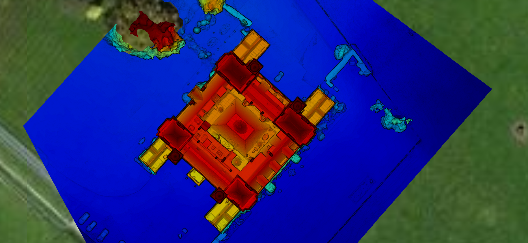
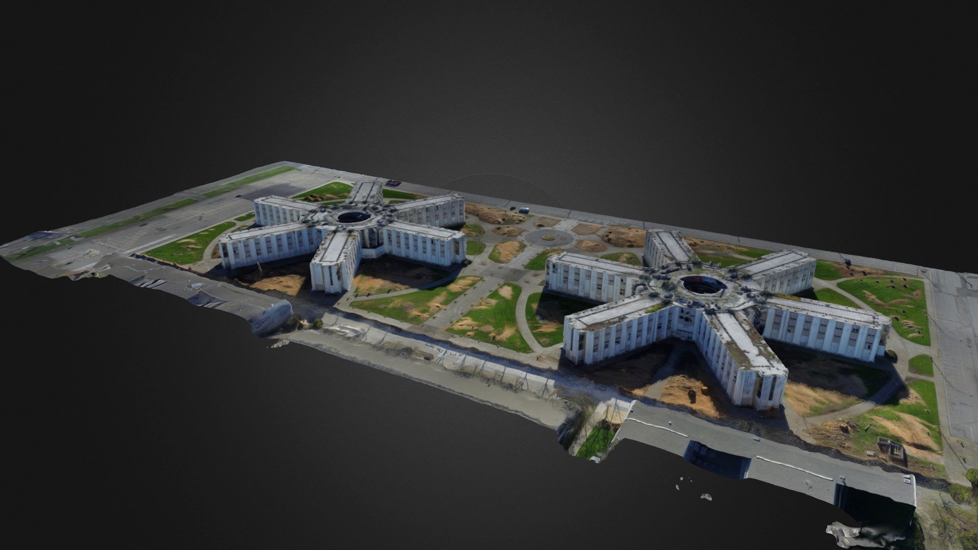
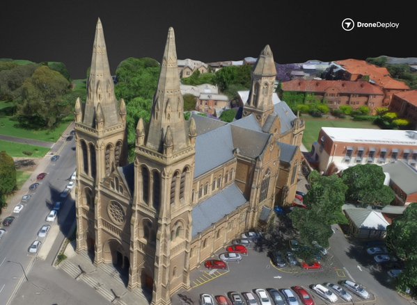
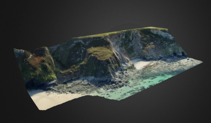
  • Aerial drone surveys are extremely accurate — collecting comprehensive data and providing high-quality images. There are also no gaps in your data due to health and safety considerations in difficult areas, meaning you get the full picture of how the land lies.

Commercial Services

Bristol Drones provides a range of commercial drone surveying and mapping services. These include:

  • Agriculture & farming
    • Forest inventory
    • Land and vegetation management
  • Environmental management
    • Coastal erosion studies
    • Hydrology/river studies
    • Illegal waste dumping
  • Academia
    • Archaeology
    • Historical site mapping
  • Land development and infrastructure planning
    • Small to medium area surveying imaging
    • Pre-cursor aerial imaging/surveying and planning for the construction sector
    • Land development updates
  • Surveying technical datasets
    • Terrain and surface modelling
    • Volumetric stockpiles studies
    • Continuous site monitoring
  • Aerial imagery for geospatial information systems users
    • Creation of new uncharted datasets
    • Mapping/charting dataset updates

If the commercial drone surveying service you require is not listed above, please get in touch with the team and we’ll see what we can do.

Non-Commercial Services

Bristol Drones delivers an array of non-commercial drone surveying and mapping services too, such as:

  • Individual domestic property and building measurements
  • Aerial views of private development land
  • Insurance assessments
  • Hard-to-locate areas

If you can’t find the non-commercial drone service you’re looking for, then please get in touch with Bristol Drones and we will do our best to accommodate you.

drone 3d mapping in bristol
3d image taken by bristoldrones

Why Choose Bristol Drones?

Drones can be used across a variety of sectors for domestic, public, commercial, or industrial use.

This means that aerial drone surveys can be conducted for various building types, such as houses, churches, schools, industrial sites, public buildings and more.

Locations Served:

Bristol Drones is a South West business based in Bristol. We’re proud to provide the entire South West with a wide variety of drone services, including the below locations:

  • Bristol
  • Bath
  • Swindon
  • Cirencester

If you’re unsure whether Bristol Drones can service the South West area you’re based in — or you’d like us to visit a location slightly further afield — then get in touch with the Bristol Drones team and we’ll see what we can do.

Our Other Drone Services:

Bristol Drones provides a huge variety of different drone services as well as surveying and mapping. Here are some of the services we provide:

  • Drone Building & Roof Inspection
  • Drone Inspection and Surveys
  • Drone Precision Agriculture
  • Drone Property Photography
  • Drone 3D Modelling & Visualisation
  • Drone Wedding Photography & Video
  • Drone Golf Course Photography
  • Drone Thermal Inspections
  • Drone 360 Panoramic Photography
  • Drone Construction Surveys
  • Drone Wind Turbine Inspections
  • Drone Bridge Inspections
  • Drone Solar Panel Inspections

Head over to each service page to find out more about our services and what you can expect from Bristol Drones.

If you’re unable to find the drone service you need in the list above, or you have another query, please get in touch with the Bristol Drones team — we’d be happy to assist.

Bristol Drones regulation & safety

Here at Bristol Drones, we believe that maintaining high safety standards and adhering to regulation standards are extremely important.

That’s why we are proud of our safe and careful drone piloting. All drone surveys and mapping services are operated by fully-certified and insured drone pilots, who are highly qualified and meet the legal and recommended requirements.

Bristol Drones is fully certified by and compliant with all major drone authorities, including the UK Civil Aviation Authority (CAA) and Drone Safe, Approved Drone Pilots and Drone Safe Register

We also maintain the high quality of all our drones, which meet all relevant and expected UK regulation standards.

Bristol Drones provide a safe and professional drone inspection service: to book a free consultation, get in touch today.

old building inspection from above with drone
3d coastal image taken with drone

FAQs

If you still have some questions about this service, check out our FAQs on drone surveying and building below:

How far can your drones see?

We use the latest and best drone technology including the Dji Matrice 210, Inspire 2, eBee SQ, Matrice 600 and Mavic 2 Pro. The advanced technology that these drones use allows them to see over 50 metres away.

Is using a drone for surveying and mapping dangerous?

Surveying and mapping with drones is completely safe. Particularly with surveying, using a drone is much safer than getting someone to climb a building, powerline or transmission tower.

Manual surveying at height comes with multiple health and safety risks, particularly when the conditions are dangerous and risky. A drone aerial survey is a safer option.

Can your drones fly in any weather conditions?

At Bristol Drones, we can fly our drones at up to a maximum wind speed of 27 mph.

Heavy rain is slightly trickier, but we will always do our best to work with whatever weather conditions we encounter and complete our project.

If you have any further questions about drone surveying and mapping or you’ll like to know more about our service, then get in touch with the Bristol Drones team here.  We’d happy to have a chat and answer any queries that you have.