Drone image of construction site bristol

Drone Volumetric Surveys

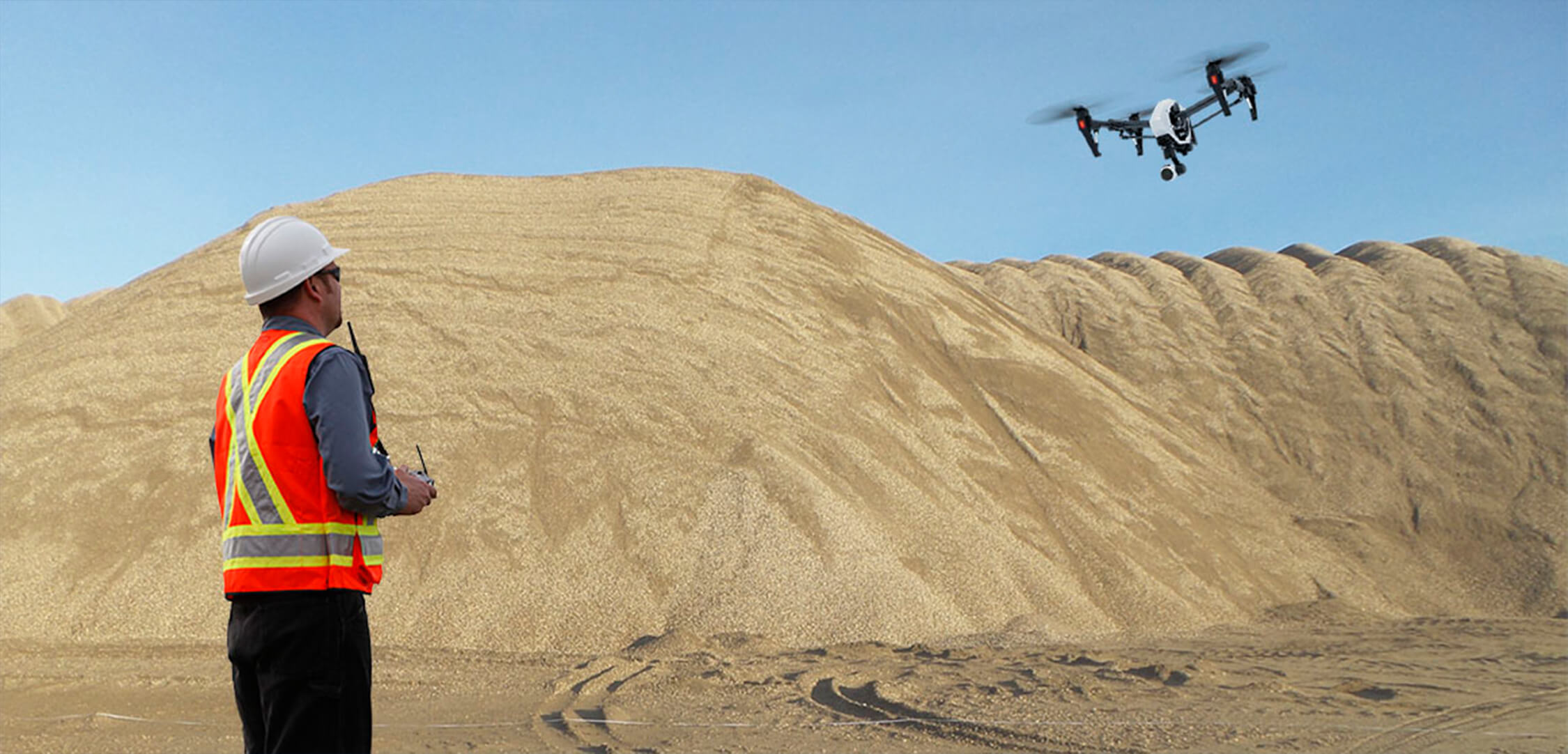
Bristol Drones offers professional stockpile volume surveys at a great value price. Our specialist team is available throughout the South West, and are equipped with the tools to help a wide range of businesses.

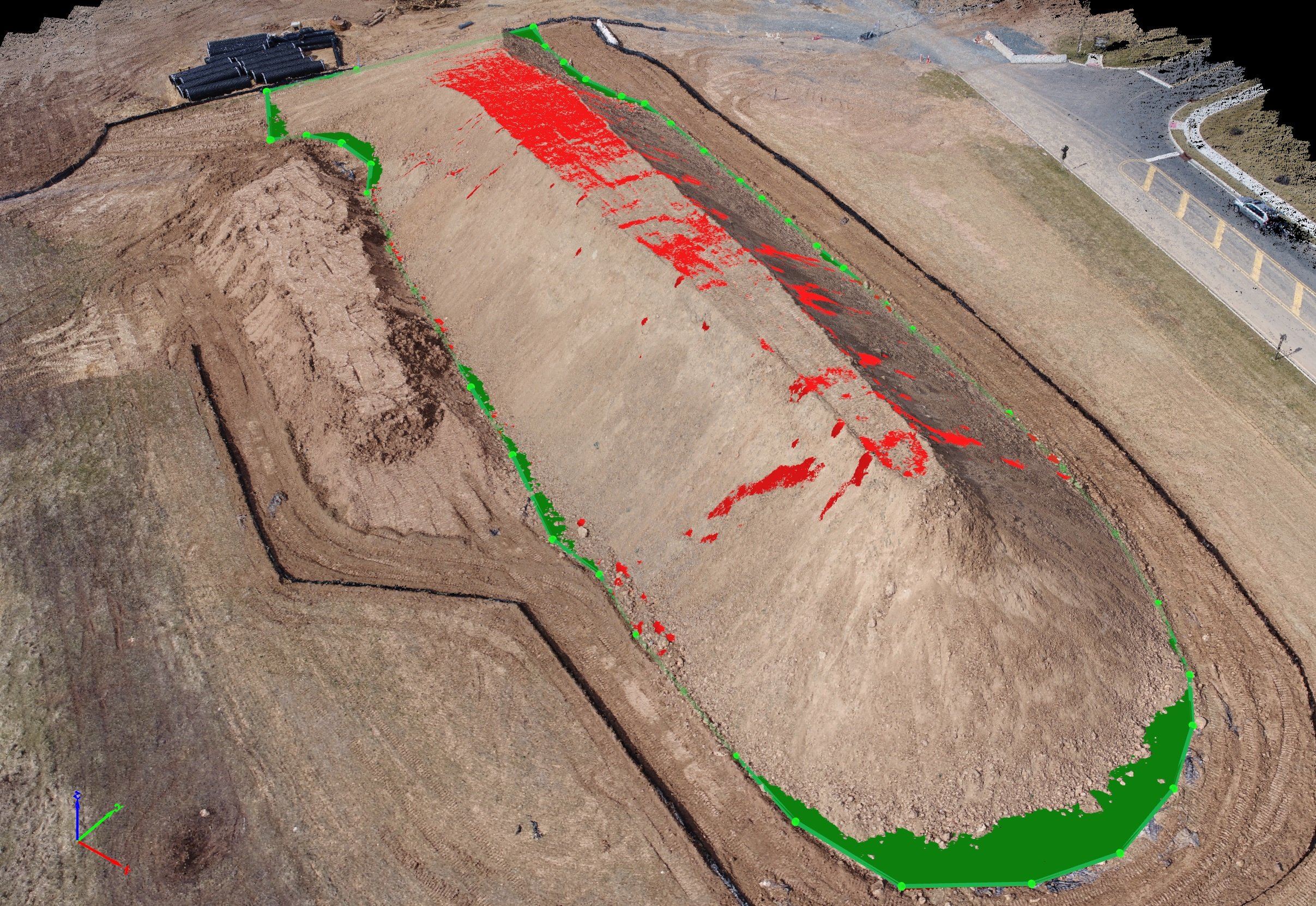
Our drone stockpile volume surveys are fast, detailed, and accurate. We’ll help your business to save money by providing up-to-date reports on inventory levels, extraction quantities or calculations for earthwork projects.

What are the benefits of stockpile volume surveys?

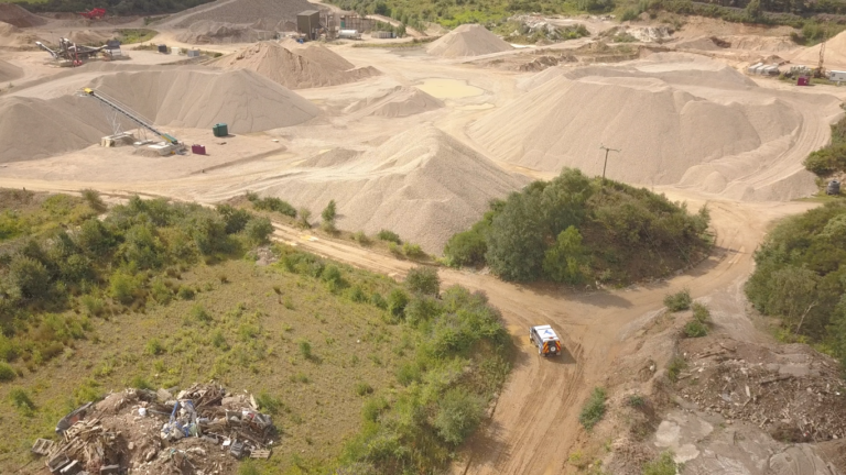
Do you work in the agriculture, construction, or mining industry? Then you know just how important it is to have an accurate record of your stockpile volumes and inventory.

Your stockpile and inventory is the thing that allows you to complete jobs and plan future work. Our drone surveys make it simpler and more straightforward.

Alongside making it easier for you to complete jobs and plan your future work, here are some of the key benefits of hiring Bristol Drones to carry out your stockpile volume surveys:

Speed: drone volume surveys are faster than traditional methods

Time is the enemy of every industry – you know yourself how often you and your company are under pressure to finish a job as soon as possible.

Our drone volume surveys are quicker to complete, meaning it takes less time for you to know if you have the correct levels of stock and inventory.

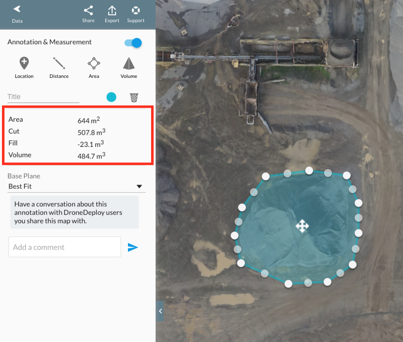
Cost: drone volumetric surveys cost less than traditional methods

Keeping costs as low as possible makes your business competitive, bringing both more work and greater financial success to your company.

Bristol Drones’ stockpile volume surveys are around half the price of volumetrics that are carried out at ground level.

Accuracy: stockpile volume surveys have a 99.4% accuracy rate

Accuracy is what gets your company work and keeps it in business – if you book in a job and have the wrong stock levels on your records, it will cost you money to replenish them or your reputation to cancel the job.

Our drone volumetric surveys have a near-perfect accuracy rate, meaning your business can focus on getting its work done without worrying about inventory.

Planning: drone volume surveys let you plan securely for the future

Being able to plan ahead helps your business to grow, along with taking precautions during any unexpected lean periods. Without having confidence in your stockpile figures, you cannot have the financial certainty to plan ahead – leaving you vulnerable.

Using a drone volume survey gives you the stockpile oversight that you need, as our precision reports give you a full picture of your figures. This means you’ll need to make fewer adjustments in your end of year accounting, allowing you the financial security you need to plan ahead.

How does a drone stockpile volumetric survey work?

Your stockpile is the materials that keep your business running, in the present and future. Because stockpiles are so important, they are the main reason for using drones on a worksite and this is why our technology works so well for volumetric surveys.

Drones begin by capturing all the stock data of your worksite

The first part of our drone volume surveys is to get a record of all the materials on your worksite. We do this by sending our drones out over the whole of your site, taking aerial photos of your inventory and using GPS to give an accurate reading of where it’s located.

All the irregularities in your inventory & stockpile are caught

Because our drones take such a forensic approach to capturing images of your worksite, it allows us to catch any irregularities. This is due to the level of detail that we get from our drone imagery. The result is that we have the true picture of your stockpile, not a rough estimate.

Drone infared
Drone being piloted

Data is used to build a precision 3D model of your entire stockpile

Once our drones capture images of your entire inventory, we take the images and create a 3D point cloud – a dense accurate model of your stockpile. This gives us a picture of your materials that is much more precise than a ground survey – many more reference points are used, which allows us to create surveys that are accurate to within 20mm.

Which industries use volumetric surveys for stockpile reports?

Drones help countless industries – from taking images of sporting events to providing detailed readings of geographical sites.

Volumetric surveys are an extremely accurate way of creating a report of stockpiles and inventory levels. This makes them perfect for in industries that need to stockpile a lot of materials and demand quick access to them.

Some of the key business sectors that our volumetric surveys help include:

  • Agriculture
  • Construction (particularly earthworks)
  • Landfill
  • Local authorities (such as councils)
  • Mining
  • Soil supplies
  • Quarrying

Why choose Bristol Drone Services for your volumetric surveys?

Bristol Drones are an experienced drone company that gives you a personal service, morning, noon, or night.

We’re fully certified and insured. This means we can guarantee you an expert service that’s safe, efficient, quick, and consistent.

Our team is trained to carry out any drone service, with a long background working for some of the biggest private and public companies in the South West.

Our fleet of drones features the highest quality makes and models, and come equipped with the latest industry technology. Some of the drones we use include:

  • DJI Matrice 210
  • DJI Matrice 600
  • eBee SQ
  • Inspire 2
  • Mavic 2 Pro

Whatever drone service you need, Bristol Drones have the experience, technology, and expertise to finish it for you.

Locations served by Bristol Drone Services

Bristol Drone Services is proud to serve the entire South West, including:

  • Bristol
  • Bath
  • Cirencester
  • Swindon

If you’re unsure if Bristol Drones covers the area you require, or you’d like us to visit an area outside of the South West, please get in touch using the contact information below.

Our Other Drone Services:

  • Drone Inspection and Surveys
  • Drone Precision Agriculture
  • Drone Property Photography
  • Drone 3D Modelling & Visualisation
  • Drone Wedding Photography & Video
  • Drone Building & Roof Inspection
  • Drone Golf Course Photography
  • Drone Thermal Inspections
  • Drone 360 Panoramic Photography
  • Drone Construction Surveys
  • Drone Wind Turbine Inspections
  • Drone Bridge Inspections
  • Drone Surveying & Mapping
  • Drone Solar Panel Inspections

Bristol Drones Is Fully Certified & Regulated

Bristol Drones is fully certified by and compliant with all major drone authorities, including:

UK Civil Aviation Authority: the CAA is a government-sanctioned body, one which is responsible for the regulation of all civil aviation in the United Kingdom.

National Air Traffic Services: NATS is the primary Air Navigation Service Provider in the UK. It looks after the regulation of all air traffic control in the country.

Dronesafe: Dronesafe is an online resource administered by the CAA and NATS. It provides information on every aspect of drone safety, both to operators and members of the public.

If you have any questions or would like to book a service, please get in touch today.

FAQs

Are drone volumetric surveys accurate?

Drone volumetric surveys are an extremely accurate way of reporting on your stock and inventory levels. Bristol Drones produces reports with an accuracy rating of 99.4%, making our surveys much more reliable and useful than traditional methods.

What is a drone volume survey?

A drone volume survey uses drone technology to create a detailed stockpile report. It works by taking images of worksites and then creating a 3D model from them.

Do surveyors use drones for their work?

Drones are used for a wide variety of commercial and private purposes. Land Surveyors often find that drones are a quicker and more accurate way of getting the data they need to complete their surveys.

drone image map